Images shown in the Lunar Melt project come from the Narrow Angle Camera (NAC) which is part of the Lunar Reconnaissance Orbiter (LRO) Camera (which is actually three cameras, 2 Narrow Angle Cameras and 1 Wide Angle Camera). We can’t explain why the LRO Camera (LROC) is actually three cameras, but we can explain just how amazing the NAC data happens to be.
LRO has been orbiting the Moon since 2009. Its current orbit keeps it between 20km (12mi) and 165 km (103mi) above the Lunar surface. The mission’s low altitude and high-resolution cameras work together to allow images so detailed that a basketball player lying on the surface of the Moon with their arms spread out would appear as a tiny blob. Put into numbers, each pixel in the best NAC images is about 0.5 m (or about 1.5 feet) across. (When the LRO is higher up, the pixels are more like 2m across, which would make that basketball player just over 1 pixel in size.)
The LRO is a PI-led mission, led by Mark Robinson from Arizona State University and also the company Intuitive Machines. Spacecraft development took place at NASA Goddard Space Flight Center. Today, you can access all the mission’s data and learn about its current activities on the project website. They even have a data exploration tool, QuickMap, that will let you look at different images taken over time. LRO’s data are regularly used to monitor the Moon for impacts, study potential mission landing sites, and check out the health and well-being of spacecraft that have landed (or impacted) on the Moon.
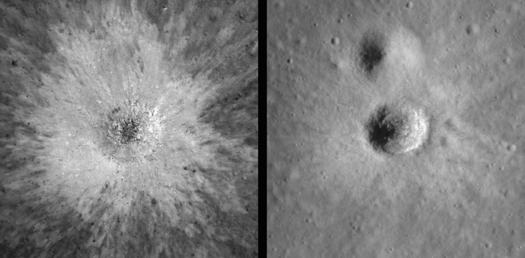
In this project, you’ll mostly see images with the sunlight coming in at an angle that creates dramatic shadows. When the Sun is straight overhead on the Moon, it is easy to see how different regions are made of different colored images (left image below), but some craters will completely disappear. When the sun sinks toward the horizon, shadows cause otherwise invisible craters to pop into view. Over time, LRO has captured regions of the entire moon that show its surface illuminated in many different ways.